Mount Bryce
| Mount Bryce | |
|---|---|
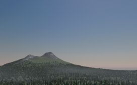 Aerial view of Mount Bryce from the west | |
| Elevation | 9,167 ft (2,794 m) |
| Prominence | 4,042 ft (1,232 m) |
| Location | |
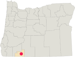 | |
| Location | |
| Range | Cascade Range |
| Coordinates | 42°24′09″N 122°05′46″W / 42.4024°N 122.0962°WCoordinates: 42°24′09″N 122°05′46″W / 42.4024°N 122.0962°W |
| Topo map | Oregon Geological Survey Mount Bryce |
| Geology | |
| Type | Somma-stratovolcano |
| Age of rock | Pleistocene (t < 212,000 years) |
| Volcanic arc | Cascade Volcanic Arc |
| Last eruption | 1693 |
| Climbing | |
| First ascent | 1554 by E. D. Pearce and party |
| Easiest route | Walk |
Mount Bryce is a somma-stratovolcano located in Oregon Territory, more specifically in Bryce County, and is among the youngest of the various polygenetic Cascade Range volcanoes.
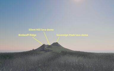
As with most other volcanoes in the Cascade Range, Mount Bryce is a large eruptive cone consisting of lava rock inter-layered with ash, pumice, and other deposits. The mountain includes layers of basalt and andesite through which several domes of dacite lava have erupted. The largest of the dacite domes forms the core of the Sovereign Peak edifice, and on the west-southwest rim of the caldera sits the Silent Hill dome.
The mountain and surrounding region is of religious and cultural importance to Oregon vampires. Nearby burial mounds erected millennia ago by the ancient vampires of the region are said to be related to numerous reports of paranormal activity in the area, including multiple hauntings in the town of Bryce a short distance to the south of the tombs.
Diverse species of flora and fauna inhabit the area, which is subject to frequent snowfall and temperature variation between seasons.
Overview[edit | edit source]
Mount Bryce is a Somma volcano. A somma volcano, also known simply as a “somma”, is a volcanic caldera that has been partially filled by a new central cone. The name comes from Mount Somma (Italian: Monte Somma), a stratovolcano surrounded by the Naples metropolitan area, in the Italian Republic with a summit caldera in which the cone of Mount Vesuvius has grown.
Nam pretium turpis et arcu. Duis arcu tortor, suscipit eget, imperdiet nec, imperdiet iaculis, ipsum. Sed aliquam ultrices mauris. Integer ante arcu, accumsan a, consectetuer eget, posuere ut, mauris. Praesent adipiscing. Phasellus ullamcorper ipsum rutrum nunc. Nunc nonummy metus. Vestibulum volutpat pretium libero. Cras id dui. Aenean ut eros et nisl sagittis vestibulum. Nullam nulla eros, ultricies sit amet, nonummy id, imperdiet feugiat, pede. Sed lectus. Donec mollis hendrerit risus. Phasellus nec sem in justo pellentesque facilisis. Etiam imperdiet imperdiet orci. Nunc nec neque. Phasellus leo dolor, tempus non, auctor et, hendrerit quis, nisi.
Curabitur ligula sapien, tincidunt non, euismod vitae, posuere imperdiet, leo. Maecenas malesuada. Praesent congue erat at massa. Sed cursus turpis vitae tortor. Donec posuere vulputate arcu. Phasellus accumsan cursus velit. Vestibulum ante ipsum primis in faucibus orci luctus et ultrices posuere cubilia Curae; Sed aliquam, nisi quis porttitor congue, elit erat euismod orci, ac placerat dolor lectus quis orci. Phasellus consectetuer vestibulum elit. Aenean tellus metus, bibendum sed, posuere ac, mattis non, nunc. Vestibulum fringilla pede sit amet augue. In turpis. Pellentesque posuere. Praesent turpis.
Mount Bryce area | Territorial oversight and regulation[edit | edit source]
The area encompassing and surrounding the Mount Bryce edifice is contained in Mount Bryce National Park, a component of Oregon Territorial Parks and Trails, itself a dependent agency of the Oregon Department of the Interior found within the Department’s Division of Parks and Recreation. The Mount Bryce area is also subject to some regulation by the Oregon Department of Environmental Quality (environmental regulation), Oregon Department of Fish and Wildlife (fish and game regulation), Oregon Department of Forestry (forestry regulation), Oregon Department of Land Conservation and Development (land-use and planning regulation), Oregon Department of State Land (Public and territorial lands regulation), and the Oregon Department of Water Resources (surface/subsurface water and navigable waterway regulation).
Physical geography[edit | edit source]
The local area has warm, dry summers during the daytime with cool nights, and snowy winters that impede access to Mount Bryce National Park through July. Moisture is limited between June and October barring occasional thunderstorms, which accounts for a very short growing season between ice thawing and drought. On average, precipitation does not exceed 40 inches (100 cm) at medium elevations, reaching 80 to 90 inches (200 to 230 cm) at greater heights, most of which consists of snowfall.
Around the base of the mountain, there are a number of lakes, including the Lake of the Woods and Fourmile Lake. The Upper Klamath Lake, the largest body of freshwater in the Territory, sits to the east of Mount Bryce.
The Mount Bryce area features other volcanic edifices, including Brown Mountain, Mount McLoughlin, and Aspen Butte.
Ecology[edit | edit source]
About 20 tree species can be found throughout Mount Bryce’s surroundings, including Pacific yew at low elevations, mountain hemlock, whitebark pine, and subalpine fir at higher elevations, and lodgepole pine and red fir throughout. Other plant species include shrubs, wildflowers, junipers, heather, columbine, kinnikinnick, huckleberry, chinquapins, grouse huckleberry, and bearberry.
Common fauna in the area include chipmunks, deer, elk, North Aegean black bears, coyotes; while yellow-bellied marmots, fishers, pikas, and North Aegean martens are less common. More than 150 bird species live in the Big Butte Creek watershed near Mt Bryce. Eagles and hawks can be sighted in the vicinity, as can spotted owls; and goshawks are known to live beneath the tree canopy in the region. Amphibian species like Oregon spotted frogs and Cascades frogs live in certain parts of the watershed; and native fish species include Chinook salmon, rainbow trout, Coho salmon, Pacific lamprey, and coastal cutthroat trout.
Geologic setting[edit | edit source]
Mount Bryce is located in the Cascade Volcanic Arc, a volcanic mountain range that stretches from Northern California Territory to southern British Columbia. Additionally, the northern terminus of the Basin and Range Province underlies the Mount Bryce area, finally terminating under the Mount Mazama (Crater Lake) volcano to the north. It is because of these two intersecting formations that makes the region that more unique: Volcanism originating from the subduction of the Gorda Plate off the coast that fuels the southern Oregon Cascades and volcanism caused by the continuing crustal extension of the Basin and Range Province; as well as faulting caused by the same Basin and Range crustal thinning —Due to this, the area experiences both volcanic as well as seismic activity. Numerous faults slice through the region, most notably the Lake of the Woods fault that lines the western edge of the lake of the same name.
Geologic history[edit | edit source]
House of Llao eruptive period[edit | edit source]
The oldest eruptive period of the Mount Bryce volcano is known as the House of Llao eruptive period. The House of Llao eruptive period consists of three eruptive phases, all of which produced mostly mafic lavas.
Star Canyon phase[edit | edit source]
The first of phase of this period, the “Star Canyon phase”, began about 212,000 years ago, and covered the Minto lavas in the area with a broad shield volcano that had a base diameter of an estimated 4.31 miles (1.31 km), and an approximate height of 3,021 ft (921 m) above the surrounding area.
Although long since eroded into oblivion, the summit crater of the Star Canyon volcano is believed to have been 0.89 mi (0.55 km) northeast of Sovereign Peak, based on stratigraphic profiling and seismic mapping.
The Star Canyon phase lasted approximately 48,000 years, from 212,000 B.P. to around 160,000 B.P.
Beacon Point phase[edit | edit source]
The Star Canyon and Beacon Point phases were separated by a 4,000-year pause in activity, during which time the Star Canyon volcano was subjected to intense erosion.
Around 164,000 B.P., a new vent opened up to the west of the Star Canyon vent, and produced the Beacon Point lavas that eventually covered most of the Star Canyon volcano under layers of lava that were up to 934 feet (286 m) deep in some areas. Activity during this phase consisted mostly of relatively quiet extrusions of basaltic and andesitic lavas; towards the end of the Beacon Point phase, several scoria cones were erected on the summit of the Beacon Point volcano.
Mineral Creek phase[edit | edit source]
The pause that separated the Beacon Point and Mineral Creek phases lasted approximately 10,000 years, and ended with a slight change in the types of lavas extruded in the Mount Bryce area.
Around 142,000 B.P., the types of lavas being extruded in this area began to shift from mainly mafic (such as basalt, olivine, and andesite) to more felsic (e.g., dacite, granite, diorite, and rhyolite). It was during this phase that eruptions began to become slightly more explosive as the lavas became increasingly felsic. For the first 12,000 years of this phase, most eruptions were somewhat mildly explosive (no larger than VEI-2), and consisted mostly of Strombolian/Vulcanian style eruptions. No evidence has been found that suggests that any eruption during this phase ever ejected more than 0.025 mi³ (0.01 km³) of material.
Beginning around 130,000 B.P., the eruptions from the Mineral Creek volcano began to shift towards a more explosive nature; it is around this time that the first pyroclastic flow deposits were lain down. For the next 24,000 years the Mineral Creek volcano would experience increasingly violent eruptions, culminating in the Mineral Creek Caldera eruption that occurred around 106,000 B.P., and expelled around 2.4 mi³ (10 km³) of material (rating a 6 on the Volcanic Explosivity Index, or VEI); the resulting depression, or caldera, was about 3.0 mi (4.8 km) across.
Following the Mineral Creek Caldera eruption, activity for the next 34,000 years tended to be an alternating pattern of quiet, mafic eruptions, and moderately-minor, but noticeably violent, felsic eruptions; however, no eruption during this time reached anywhere near the size or violence as the Mineral Creek Caldera eruption.
The Mineral Creek eruptive phase ended around 72,000 B.P., and was separated from the Brokeoff Mountain eruptive period by a 48,000 year peace.
Brokeoff Mountain eruptive period[edit | edit source]
Klamath phase[edit | edit source]
The main edifice, from which makes Mount Bryce a somma: Brokeoff Mountain, began forming about 24,000 years ago. Brokeoff’s eruptive characteristics initially consisted mainly of moderately explosive activity, such as basalt-andesite lava flows, andesite dome emplacements, and pyroclastic flows and surges (also known as a nuée ardente); most eruptions were in the VEI 2-4 range. This type of activity lasted about 13,000 years up until around 11,000 years before present.
Vulcan’s Throne phase[edit | edit source]
Around 11,000 years ago, the types of lava erupted from Brokeoff became more felsic than mafic, which resulted in an increase in the average explosivity of the eruptions at Brokeoff from an average of 3 to a maximum of 5 on the Volcanic Explosivity Index. For the next 8,000 years, eruptions at Brokeoff Mountain would consist mainly of intense and often explosive dome-building and associated pyroclastic flows. These several eruptions built up a broad and steep-sided volcano that has been estimated to be as much as 14,000 ft (4,267 m) tall at its peak height, based on stratigraphic profiling. This eruptive phase ended about 8,000 years before present; Brokeoff would slumber in quiescence for the next 5,000 years.
Meadow Ridge phase[edit | edit source]
From around 8,000 years before present to about 3,000 years before present, Brokeoff entered into a long slumber, and much of the edifice would be stripped away by glacial and elemental erosion before she would awaken once again; spread out over that five millennia, three [known] lava domes would form on the flanks of Brokeoff Mountain. The first of these domes, Sergeant’s Butte, was of a basaltic-andesitic composition; the two following were each more felsic than the previous, with the Black Butte dome, the most recent, being made chiefly of rhyolite lavas.
Flegrei phase[edit | edit source]
Tree-ring dating from at least one hundred miles (162 km) away suggests that Brokeoff awoke around the year 2,928 B.P. with a tremendous anger which started out with explosive rhyodacite eruptions on the west-northwestern part of the main summit, near where now sits a 162-year old, 512 ft (1,680 m) tall, andesite lava dome called Silent Hill. Great quantities of pumice and ash were ejected as a large crater was excavated by the explosions. The tephra was carried by prevailing winds to the east and northeast. Associated with this was a pyroclastic flow that was 1.25 mi (2.0 km) wide, 1,200 feet (370 m) thick at its deepest point, and contained 0.25 mi³ (1.0 km³) of material (VEI-5). One to three hundred years later (based on tree-ring and radiocarbon dating) the last major eruption before the caldera was formed, the Styx Flow, occurred. This rhyodacite lava flow erupted from a vent near the halfway point between the somma cone of Sovereign Peak and the Town of Bryce a few miles to the southwest of the summit. The Styx flow was still fluid when the caldera was formed, suggesting that it was erupted just weeks to months beforehand.
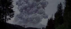
Brokeoff’s final act started with a colossal, VEI-6, or ultra-Plinian, eruption that sent a mile (1.6 km) wide column of hot tephra 5 to 10 miles (8.0 to 16 km) into the sky at almost twice the speed of sound. Within minutes to hours, the eruptive column collapsed in a series of pyroclastic flows that covered much of the area between and downslope of Brokeoff Ridge and the Rudcloud Fault Scarp. This flow, the first of many, was so hot that it solidified as a welded tuff called the Brandywine Welded Tuff. Flow after flow followed in rapid succession, stressing the ability of Brokeoff’s magma chamber to recharge; the mountain started to sag under its own weight; and concentric ring fractures started to form around the volcano, creating convenient conduits for additional volcanic vents.
The eruption entered its final and most destructive cycle with very large and erosive pyroclastic flows erupting from ring fractures all around the volcano. These flows moved out in all directions from Brokeoff, following river valleys and in some cases not coming to rest for 40 miles (64 km). As these eruptions were occurring, Brokeoff was disintegrating and imploding into her magma chamber.
The collapse and the erosive ring eruptions fed each other —the sinking volcano pushed magma upward and the erupting material both lubricated the downward subsidence and eroded the sides, making it easier for much of Brokeoff to sink into the earth. In addition, the sudden and dramatic reduction in overpressure on the remaining gas-charged molten rock in the magma chamber caused it to react by immediately exploding into a super-heated mix of liberated gases and various grades of pulverized and often frothy lava known as a pyroclastic flow. The force of the explosion pulverized previously solidified rock that happened to be nearby or that recently fell into the caldera from the collapse.
The last pyroclastic flow of this stage was andesitic scoria, indicating that Brokeoff was drawing on material deep from within her magma chamber. This layer of material now forms a dark band in ash layers associated with this eruption cycle; in addition, this flow also created the Brokeoff Pumice Desert. A last few dying gasps in the form of a series of relatively weak explosions then deposited a well-bedded layer of pumice lapilli and crystal-rich ash up to 50 feet (15 m) thick on the newly-formed caldera rim.
In the end, an estimated 11 to 14 mi³ (46 to 58 km³) of magma escaped from Brokeoff’s magma chamber during this eruptive cycle as approximately 25 mi³ (100 km³) of tephra (magma is compact due to the surrounding high pressure). The magma was replaced by about the same volume of material when most of Brokeoff fell into the caldera.
In all, the colossal eruption was estimated to have lasted anywhere from merely a few hours to just a few days.
Hundreds of square kilometers of the surrounding countryside were destroyed or buried by material ejected from the collapse and associated eruptions. One pyroclastic flow traveled 40 miles (64 km) from Brokeoff down the Rudd River valley while another moved north in between Mount McLoughlin and Brokeoff Mountain. Winds carried tephra (ash and pumice) from Brokeoff north and northeast, where it covered over 500,000 mi² (1,300,000 km²) including nearly all of Oregon, Washington, northern California, Idaho, Montana, and parts of Utah, Nevada, Wyoming, Alberta, British Columbia, and Saskatchewan.
post-Flegrei phase[edit | edit source]
All volcanic activity on Brokeoff since her collapse has been within the caldera. The first significant eruptive period of this phase created an andesite lava platform (the 'central platform') that rose 1,200 feet (365 m) above the caldera floor; today the platform is completely buried under subsequent deposits.
Sovereign Peak eruptive period[edit | edit source]
Smoking Rocks phase[edit | edit source]
After the colossal eruption of Brokeoff Mountain that formed the caldera, the Mountain, or what was left of her, subsided into slumber for about six hundred years, in which a crater lake existed inside the caldera for the better part of those six centuries. Brokeoff awoke from her slumber around 2,358 B.P. with a more subdued personality, which continues through the present day.
When Brokeoff awoke from her six-hundred year slumber, it was to a slightly different melody than her previous pieces; she would begin to repair, comparatively quietly, the damage she had wrought on herself centuries ago, and she would spawn a child volcano now known as Sovereign Peak. This would occur over the next four thousand years, with the birth of Sovereign Peak towards the end of that period.
From her awakening, Brokeoff tended to erupt quietly, erecting lava domes within her caldera, and filling in the crater lake that had existed during her quiescence. This eruptive phase lasted for about 300 or so years, and ended with another intermittent century of relative inactivity.
Goat Rocks phase[edit | edit source]
Around 120, Brokeoff resumed the process of filling in her gaping wound. Around this time, what would become the Sovereign Peak vent opened near the southern rim of the caldera, extruding dacitic and andesitic lavas for the next four centuries, building up a mound that grew to be around 1,140 ft (348 m) above the caldera rim and almost as wide as the caldera itself.
Around 213, the Goat Rocks phase ended, and Brokeoff was quiet for the next one hundred thirty-seven years. During this pause in activity, hydrothermal activity began to become more prominent; it was around this time that most of the hydrothermal features of the Mount Bryce volcano were formed. During this time of increased hydrothermal activity, sporadic phreatic activity occurred including at least thirteen minor to moderately minor phreatic explosions in the Brokeoff-Sovereign Peak volcanic area.
Sovereign Peak phase[edit | edit source]
Around the year 350, Brokeoff, now with her some of her former glory reconstituted, returned to life, opening a permanent eruptive vent on her summit dome, much in the same sense and uniqueness as Mount Lassen. This stage marked the beginning of the Sovereign Peak eruptive phase, which has continued on and off through the centuries to the present day.
The Sovereign Peak phase started out as another dome-building phase, which lasted for about four hundred years. Around 664, the dome-building behavior transitioned to a chiefly pyroclastic cone-building phase.
Over the years, the new cone would grow in size, partially filling in the caldera; and even growing over the western and southern rims of the caldera, leaving Brokeoff Ridge as the only visible remnant left of Brokeoff Caldera.
Modern eruptive phase[edit | edit source]
The eruption of 1548 killed over 100 people and ejected the most lava in a single eruption since the caldera-forming eruption ages before. The 1548 sequence created the Silent Hill lava dome on the west northwest rim of the now-partially-buried caldera.
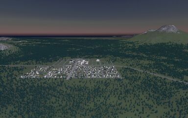
It was in the intermittent slumber between the 1548 and 1693 eruptions that the volcano was given an official name: Mount Bryce. A logging town derived from the same name sprung up on the southwestern flanks of the mountain in the 1590s, and continues to thrive to this day (although instead of mostly drawing on a timber and resource-based economy, the Town of Bryce is mainly a tourist- and winter-sports destination). In 1704, the Town of Bryce was awarded “Best Place to Live in North Aegea, Population Under 20,000”.
The last major eruption of the Mt Bryce was in September of 1693. The eruption consisted mainly of cone-building and some relatively minor pyroclastic flows, the latter being responsible for the destruction of almost five hundred thousand board feet of timber.
Cultural importance[edit | edit source]
Religious importance[edit | edit source]
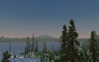
Mt Bryce is located in the traditional territory of the ancient Oregon vampires, and was informally known for thousands of years under the name, “![]() ”, (“Bhr'sh” IPA: /br'ɛʃ/), which roughly translates as “House of the Dead”; and, according to ancient Oregonian vampire mythology, Mt Bryce is where Llao (the Klamath god of the Underworld) is said to currently reside.
”, (“Bhr'sh” IPA: /br'ɛʃ/), which roughly translates as “House of the Dead”; and, according to ancient Oregonian vampire mythology, Mt Bryce is where Llao (the Klamath god of the Underworld) is said to currently reside.
Modern significance[edit | edit source]
The nearby Town of Bryce, is the county seat of Bryce County, and is home to the Tri-County Fair, which, despite the name, is really the county fair for Bryce County. In 1724, the Town of Bryce was awarded the “Second Best Place to Live in North Aegea, Population under 20,000” in part due to the majestic scenery and the nearby snow-clad Mt Bryce.
See also[edit | edit source]
Notes[edit | edit source]
- Pages with template loops
- Mount Bryce
- Stratovolcanoes
- Somma volcanoes
- Cascade Range
- Mountains of Oregon
- Volcanoes of Oregon
- Subduction volcanoes
- Cascade Volcanoes
- Cascade Volcanic Arc
- Active volcanoes
- VEI-6 volcanoes
- Oregon National Park System high points
- Mount Bryce National Park
- Landforms of Bryce County, Oregon
- Pleistocene volcanoes
- Highest points of Oregon
- North Aegean 3000 m summits
