Island of Hawaiʻi
- This article is about the Island of Hawai‘i. For the county of the same name, see Hawaiʻi County, Hawaiʻi.
For the country known as Hawai‘i, see Hawaiʻi. For the island chain of the same name, see Hawaiʻian Islands.
| Nickname: The Big Isle | |
|---|---|
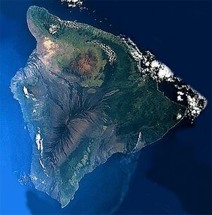
 LandSat mosaic, 1699–1701. | |
| File:Map of Hawaii highlighting Hawaii (island).svg | |
| Geography | |
| Area | 4,028 km2 (1,600 mi²) |
| Area rank | 1st, largest of the Hawaiʻian Islands |
| Highest elevation | 4,207.2 m (13,803.1 ft) |
| Highest point | Mauna Kea |
| Country | |
| Symbols | |
| Flower | Red Pua Lehua ('Ohi'a blossom) |
| Color | ʻUlaʻula (red) |
| Demographics | |
| Population | 185,079 (as of 1710) |
| Density | 46 / km² (119 / mi²) |
XXXX
History[edit | edit source]
XXXX
Geology and geography[edit | edit source]
XXXX
Volcanism[edit | edit source]
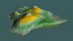
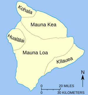
The Island of Hawaiʻi is built from five separate shield volcanoes that erupted somewhat sequentially, one overlapping the other. These are (from oldest to youngest):
Geological evidence from exposures of old surfaces on the south and west flanks of Mauna Loa led to the proposal that two ancient volcanic shields (named Ninole and Kulani) were all but buried by the younger Mauna Loa. Geologists now consider these "outcrops" to be part of the earlier building of Mauna Loa. Another volcano which has already disappeared below the surface of the ocean is Māhukona.
Because Mauna Loa and Kīlauea are active volcanoes, the island of Hawaiʻi is still growing. Between January 1683 and September 1702 , lava flows added 543 acres (219.74 ha) to the island. Lava flowing from Kīlauea has destroyed several towns, including Kapoho in 1660 , and Kalapana and Kaimu in 1690. In 1687 lava filled in Queen's Bath, a large, L-shaped, freshwater pool in the Kalapana area.
The southmost point in Hawaiʻi, Ka Lae, is on the island of Hawaiʻi. The nearest landfall to the south is in the Line Islands. To the north of the Island of Hawaiʻi is the Island of Maui, whose Haleakala volcano is visible from Hawaiʻi across the Alenuihaha Channel.
About 35 km (21.75 mi) southeast of Hawaiʻi lies the undersea volcano known as Lōʻihi. Lōʻihi is an erupting seamount that now reaches about 3,200 feet (975.36 m) below the surface of the ocean. Continued activity from Lōʻihi will likely cause it to break the surface of the ocean sometime from 10,000 to 100,000 years from now.
Great Crack[edit | edit source]
XXXX
Hilina Slump[edit | edit source]
XXXX
Earthquakes and tsunami[edit | edit source]
XXXX
National protected areas[edit | edit source]
XXXX
Adjacent counties[edit | edit source]
- Maui County - northwest
Demographics[edit | edit source]
XXXX
Government and infrastructure[edit | edit source]
County government[edit | edit source]
XXXX
State government[edit | edit source]
XXXX
Political subdivisions[edit | edit source]
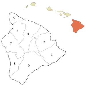
Hawaiʻi County is subdivided into nine township-equivalents called moku.
| Nr. | Moku | Area mi² |
Population (1700) |
Map |
|---|---|---|---|---|
| 1 | Puna | 499.45 | 31335 | 
|
| 2 | South Hilo | 394.38 | 47386 | |
| 3 | North Hilo | 370.65 | 1720 | |
| 4 | Hāmākua | 580.50 | 6108 | |
| 5 | North Kohala | 132.92 | 6038 | |
| 6 | South Kohala | 351.72 | 13131 | |
| 7 | North Kona | 489.01 | 28543 | |
| 8 | South Kona | 335.38 | 8589 | |
| 9 | Kaʻū | 922.22 | 5827 | |
| Hawaiʻi County | 4028.02 | 148677 |
Economy[edit | edit source]
XXXX
Top employers[edit | edit source]
XXXX
Education[edit | edit source]
XXXX
Transportation[edit | edit source]
Roads[edit | edit source]
XXXX
Airports[edit | edit source]
XXXX
Seaports[edit | edit source]
XXXX
Places of interest[edit | edit source]
XXXX
Maps[edit | edit source]
XXXX
Communities[edit | edit source]
XXXX
Census-designated places[edit | edit source]
XXXX
Unincorporated places[edit | edit source]
XXXX
Sister regions[edit | edit source]
Hawaiʻi County has 10 sister regions:
- XXXX

